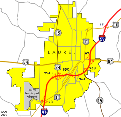
Interstate 59 bisects the city while it wraps around the downtown area. The Interstate maintains four lanes throughout the city, with an extremely sharp turn at the aformentioned "Laurel Curve". This stretch of twisting roadway sees a reduction in speed limits to the Interstate sub-standard of 45 mph with closely placed interchanges to complicate things. U.S. 84 and Mississippi 15 also join up for some mileage near Downtown and the curve. Numerous warning signs and flashing lights are in place for the sharp curve of the Interstate with the speed limit reduction rigorously enforced.

| Southbound on-ramp to Interstate 59 from Exit 95C, located south of downtown. Note that U.S. 84 west and Mississippi 15 north are shown secondary to the guide sign with shields. This guide sign is one of the few newer ones with standard MUTCD font. Photo taken 06/01.
|
The only route to retain its original Laurel city limits routing. U.S. 11 serves the sleepy downtown area, paralleling Interstate 59 to the west. It intersects with the Interstate to the north and south of the city at Exits 90 and 99.

| 4th Avenue northbound at U.S. 11 near downtown Laurel. This older shield assembly is at the end of the roadway and includes an old Interstate 59 Mississippi trailblazer. U.S. 84 and Mississippi 15 trailblazers are posted pointing towards Interstate 59 in either direction, but are leftover from when the two highways shared pavement with U.S. 11 through here. Photo taken 12/08/00.
|

| A return visit to the area during the Summer of 2001. Note the mast arm traffic light assembly. The downtown areas of both Laurel and Hattiesburg use these traffic light assemblies instead of the standard span wire setups that are prevelent throughout the state. Photo taken 06/01.
|

| Detail of the faded Interstate 59 Mississippi shield in the above pictured assembly at U.S. 11 from 4th Avenue. Photo taken 12/08/00.
|

| One of three sets of sign banks in a traffic island at the intersection of U.S. 11 and old Mississippi 15 to the northeast of downtown. This set of shields faces U.S. 11 northbound, and directs traffic to the U.S. 84 Exit 97 interchange for all Interstate 59 bound traffic. Old Mississippi 15 does have a partial interchange with the same Interstate, but no ramps are offered in the southbound direction. Photo taken 06/01.
|

| Another vantagepoint of the signs at the U.S. 11 north intersection with old Mississippi 15. The Mississippi 15 south shield should have a "TO" banner placed above it. However, the roadway does transition into the state route a short distance to the south. U.S. 84 originally was signed with U.S. 11 through here, but now is accessible at the Exit 97 interchange. Photo taken 06/01.
|

| A closer look at the shields in the above photograph. Photo taken 12/08/00.
|

| Although U.S. 11 just passed by old U.S. 84 and nearby Exit 97 (where U.S. 84 ties into Interstate 59 from the east), a U.S. 84 trailblazer is shown to southbound traffic at the same intersection with old Mississippi 15. Again this was originally a shield posted for the U.S. 11/84 overlap that was slightly altered with a TO banner. Photo taken 06/01.
|

| Another perspective of the shield assembly facing southbound U.S. 11 traffic. Unlike with the northbound shields, a TO banner is affixed above the Mississippi 15 shield. Traffic turning left passes under Interstate 59 before leaving the Laurel area en route to Richton and the De Soto National Forest. Photo taken 06/01.
|
The highway bypasses downtown Laurel on Interstate 59 between the Exit 95A/B cloverleaf and Exit 97. Many of the downtown area roadways are convuluted due to the placement of a railroad line through downtown. This indirect in-town routing most likely led MDOT to relocate the highway along Interstate 59 for the short two mile spell.

| A sign bridge doulbing as support for traffic lights on U.S. 84 east/Mississippi 15 south at Interstate 59 southwest of downtown Laurel. U.S. 84 and Mississippi 15 enter the interchange overlapped from the north. The southbound ramp for Interstate 59 is situated to the right, with U.S. 84 and Mississippi 15 continuing within the cloverleaf interchange to the next ramp. Photo taken 06/01.
|

| U.S. 84 and Mississippi 15 are oriented in a north-south fashion at this interchange. The two highways hop onto Interstate 59 north, as it curves in an easterly trajectory south of the downtown area. Waynesboro is included on this guide signage as it is the next control point along U.S. 84 east. Photo taken 06/01.
|

| U.S. 84 westbound entering Interstate 59 southbound in eastern Laurel. Collins is shown on this guide sign, as it is the control point for U.S. 84 west of Laurel. Continuing straight takes one on old U.S. 84 to U.S. 11. Photo taken 06/01.
|
Rounding out the route introduction is Mississippi 15. The highway is an important north-south corridor throughout central and northern Mississippi. It brings traffic from Beaumont and Richton to the south into Laurel, funnelling traffic north to Bay Springs as it exits the city. This route hops aboard Interstate 59 between Exit 95A/B and Exit 96B. The old routing continues from Exit 96B into the downtown area at U.S. 11.

| Old Mississippi 15 northbound at U.S. 11. This triangular shaped traffic island is home to three banks of highway shields (two of which retain Interstate 59 Mississippi shields). Mississippi 15 would have originally turned to the left along U.S. 11 southbound into downtown here. U.S. 84 would have been cosigned with U.S. 11 as well. The map above shows this intersection along U.S. 11 just to the southwest of Exit 97 of Interstate 59. Photo taken 06/01.
|
Page Updated July 7, 2002.
